|
Page
1 continued - Archaeology
South-East
6.3 The walkover survey was largely unfruitful. The field had recently
been harvested, and the ground cover comprised thick straw stubble and
grass, reducing the likelihood of observing artefactual material to
practically nil. No comprehensive fieldwalking survey was attempted.
The field has been subjected to modern arable cultivation for many years,
precluding the survival of any earthworks, or other form of upstanding
archaeological feature.
6.4 The fields were generally flat in aspect
7.0 ARCHAEOLOGICAL POTENTIAL OF THE SITE
7.1 A preliminary review of the cultural heritage evidence detailed
earlier indicates that the site has archaeological potential. This archaeological
potential is considered by period and then in terms of significance.
7.2 Prehistoric: Palaeolithic – Neolithic
7.2.1 No finds relating to the Palaeolithic and only one artefact of
Mesolithic date have been found within the study area, and although
chance finds of unstratified worked flints are a possibility from either
period, these are of relatively limited archaeological value due to
their secondary deposition. Two Neolithic finds within the study area
would also suggest limited human activity in the immediate landscape
during this period. However, many Early Bronze Age traditions have their
antecedents in the Late Neolithic, and because of the significant nature
of
the Bronze Age activity nearby, as identified from air photographs,
the identification of Neolithic material, or structures, within the
site boundaries, should not be entirely dismissed.
7.2.2 The potential of the appraisal site for this period is low, with
only a moderate potential for Neolithic material.
7.3 Prehistoric: Bronze Age
7.3.1 Two Bronze Age finds have been made within the study area itself,
a cremation urn probably associated with a ploughed-out round barrow,
and a socketed bronze axe. In addition, the locality around the site,
just to the west, is a seminal site for this period. Ardleigh itself
has become synonymous with a typological subgroup
of the Deverel-Rimbury Bronze Age tradition. In Britain it is during
this period that the archaeological evidence reveals the emergence of
agriculturally based sedentary communities, foreshadowing the modern
intensively farmed landscape.
As such the site is within a particularly archaeologically sensitive
area. Cropmark evidence indicates the presence of at least three barrow
cemeteries of this period within the site, and there may also be field
systems of a similar date.
7.3.2 The potential for the recovery of archaeological data relating
to this period within the site is considered to be high.
7.4 Prehistoric: Iron Age
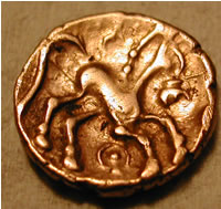
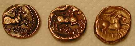
7.4.1 Considerable numbers of coins of this period, many of them gold,
have been recovered from around the locality of the site. The exact
circumstances and nature of their deposition is still unclear, and the
recovery of further examples, and their contextual study, is still very
much a work-in-progress. Nevertheless, the amount of material found
indicates that activities of some importance were taking place in this
area during this period, involving both single coin loss and the burial
of hoards. Many of the rectilinear cropmarks that exist on the site
may also date from this period, although the two forms of evidence cannot
at present be linked in any specific or certain manner.
7.4.2 The potential for the recovery of archaeological data relating
to this period within the site is considered to be high.
7.5 Roman
7.5.1 One archaeological find of Roman origin has been found within
the study area, comprising one gold coin. This is of little significance.
Of more interest are the linear cropmarks that exist within the site.
Some of these may be of Romano- British date, indicating re-use of existing
agrarian features, and probably becoming embedded into a complex network
of contemporary Roman field systems.
7.5.2 The potential for the identification of archaeological data relating
to this period within the site is considered to be high.
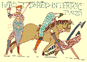
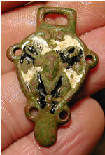
7.6 Anglo-Saxon
7.6.1 Little is known about Anglo-Saxon in this area, although the settlement
probably formed one larger estate The present church may not have existed
until at least the later Saxon period. A number of Saxon artefacts
have been recovered in recent years during metal-detecting forays, but
it is difficult at present to interpret them as anything more than casual
losses.
7.6.2 The potential for the identification of archaeological data relating
to this period within the site is considered to be low.
7.7
Medieval
7.7.1 Three finds relating to the study area are recorded by the SMR
for this period, although all three are contained within the churchyard
and are contextually specific to that site. The appraisal area itself
was probably agricultural land at this date, and there may therefore
be potential for the remains of field systems to be encountered, even
though they are not readily apparent through examination of the cropmark
evidence. One of the cropmarks may represent a possible windmill mound
of medieval or later date.
7.7.2 The potential for the identification of archaeological data relating
to this period within the site is considered to be moderate.
7.8 Post-Medieval
7.8.1 The examination of post-medieval maps clearly shows that for much
of this period the appraisal site itself, and much of the surrounding
landscape have been arable farmland, subject to varying degrees of enclosure.
It is unlikely therefore, that any unrecorded archaeological features
of later Post-medieval date lie within the site. However, the former
existence of short-lived agricultural buildings not represented on the
maps should be borne in mind, and one of the cropmark features may relate
to a possible windmill mound of medieval or later date.
7.8.2 The potential for the identification of archaeological data relating
to this period within the site is considered to be moderate.
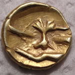  
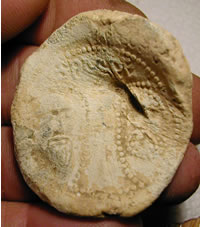
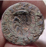
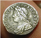
Celtic
gold finds from 70 BC
8.0
EXISTING IMPACTS ON ARCHAEOLOGICAL POTENTIAL
8.1 The site is situated on sand and gravel substrate. Sandy soils such
as these tend to be acidic in nature. The acidity will probably have
adversely affected the survival of bone material, metalwork and low-fired
prehistoric and Saxon pottery. Other pottery, i.e. of the Roman and
Medieval periods may still be in reasonable condition but survival (of
all other artefactual material) can be very variable depending on the
localised burial environment. Sub-surface survival of flint though,
is likely to have been good.
8.2 The area is likely to have been under a mixed arable/pastoral regime
from the late prehistoric period onward. Intensive cultivation by modern
farm machinery is likely to have been extensive. This will have impacted
upon the archaeological resource to some degree, with truncation of
sub-surface deposits expected.
8.3 The cropmark evidence clearly indicates that the prehistoric, and
Roman landscape will not necessarily have respected the modern field
and settlement pattern. Consequently, such prehistoric and Roman settlements
that have existed, and potentially survive beneath the plough soil may
not relate to the existing landscape form.
8.4
In summary it would appear that past and present arable cultivation
is likely to have had the most adverse impact on the likely archaeological
resource of the site area, although to what degree is uncertain. Acidic
ground conditions may have destroyed or badly damaged the preservation
of specific types of material remains.
 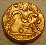 
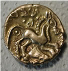
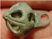
Celtic
gold finds from 50 BC
9.0
SUMMARY OF POTENTIAL AND CONCLUSIONS
9.1 A desk-based assessment can generally only consider the potential
of a site in principle. As is the case here, its conclusions usually
require testing by fieldwork in order to confirm whether remains are
actually present and, if this is the case, to establish their character,
condition and extent and thus indicate the weight that ought to be attached
to their preservation. It must always be acknowledged that remains of
a type for which there is no prior evidence may be found on a site by
fieldwork.
9.2 The potential for discovery of new sites has been revealed by a
review of known archaeological sites in the immediate vicinity. The
estimated potential for sites and/or findspots being located within
the appraisal area can be summarised thus:
Palaeolithic
- Low
Mesolithic - Low
Neolithic – Moderate
Bronze Age - High
Iron Age - High
Romano-British - High
Anglo-Saxon - Low
Medieval - Moderate
Post-Medieval - Moderate
9.3 The cartographic evidence has revealed a relatively static landscape,
in which field enclosure has been the predominant factor. Agricultural
practices, especially those of the 20th-century may have truncated or
even destroyed shallow archaeological deposits, but deeper features
(pits, ditches, building foundations, etc.) may still survive. However,
cropmark evidence, combined with recent excavations in the locality,
seems to suggest that a Late Bronze Age to Romano-British agricultural
landscape may have once been deeply embedded within the landscape.
9.4 To conclude, the area and surrounding environs are rich in archaeological
material, especially from the Bronze Age through to the Romano- British
period. By comparison, a comparative hiatus of human activity seems
to
have occurred after this period, resulting in a concomitant dearth of
material, right through till the present time. However, the area pays
testament to the concept of landscape as a palimpsest, with surviving
layers of evidence from different historical periods superimposed upon
each other. Therefore on consideration
of a number of lines of evidence, the appraisal site is considered to
be of generally high archaeological potential.
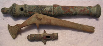
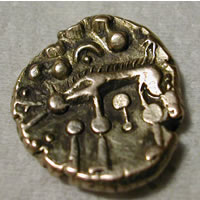
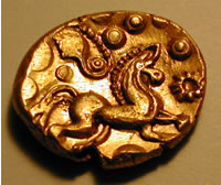
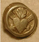
Celtic
gold hoard 1stC
10.0 RECOMMENDATIONS
10.1 A number of preliminary recommendations will be offered in this
section to provide a suggested framework for future research. The site
is not under threat from development, and is currently not under intensive
agricultural cultivation.
10.2 A useful first stage would be to continue with non-intrusive methods
of investigation. Large and complex systems of cropmarks are recorded
on aerial photographs of the site, many of which have been plotted onto
base maps. However, it would be a worthwhile exercise to complete this
process to produce a complete record. This is a reasonably technical
procedure as the photographs are oblique and would need to be rectified
before plotting could take place. This can be carried out by utilising
a number of GIS-based software programs.
10.2 A second stage of non-intrusive fieldwork would be to conduct a
geophysical survey of the site. Although gravel subsoils are not ideal
for resistivity, the clarity of the cropmarks suggests that magnetometry
would produce good results. The ability to check the geophysics results
against the rectified cropmark plots would
allow the geophysics plot to be used as a predictive tool to identify
further areas of archaeological significance that may not have produced
cropmarks.
10.3 Completion of the above tasks would provide a comprehensive set
of accurately located targets that could then be investigated by trial
trenching. An evaluation in the form of trial trenching would help to
establish with a greater degree of certainty the presence or absence
of any archaeological features, and would provide a relatively economical
method for establishing the character, dating and degree of preservation
of the cropmarks. This information would then be invaluable in formulating
research designs for any projected future research based
fieldwork on the site, which should incorporate a thorough study of
the extensive metal-detecting finds that have been recovered over recent
years.
11.0 ACKNOWLEDGMENTS
Archaeology South-East would like to thank the following for their help
and advice in the preparation of this report: Colchestertreasurehunting,
Nigel Brown, Sally Gale and Pat Connell (Essex County Council)
The staff at the Essex County Records Office, both in Colchester and
Chelmsford.
All
maps and ariel photos are available to view by members only
12.0
The next stage is a full Geophysic investigation of
the site.
REFERENCES
Bedwin, O. (ed.), 1996. The Archaeology of Essex, Essex County Council.
Brown, N., 1999. The Archaeology of Ardleigh: Excavations 1955-1980,
East Anglian Archaeology 90.
Brown, N. & Germany, M., 2002. ‘Jousting at Windmills? The
Essex Cropmark Enclosures Project’, Essex Archaeology and History
33.
Brown, N., Knopp, D., & Strachan, D., 2002. ‘The archaeology
of Constable Country: the crop-marks of the Stour Valley’, Landscape
History 24.
Buckley, D.G. (ed.), 1980. Archaeology in Essex to AD 1500, Council
for British Archaeology Research Report 34.
de Jersey, P., 1996. Celtic Coinage in Britain, Shire.
Erith, F.H., 1964. Colchester Archaeological Group Quarterly Bulletin
.
Erith, F.H., 1968. Colchester Archaeological Group Quarterly Bulletin
Field, J., 1993. A History of English Field-Names, Longman.
Hedges, J., 1980. ‘The Neolithic in Essex’ in Buckley 1980.
Holgate, R., 1996. ‘Essex c.4000-1500 BC’ in Bedwin 1996.
Hunter, J., 1999. The Essex Landscape, Essex Record Office.
Kemble, J., 2001. Prehistoric and Roman Essex, Tempus.
Morant, P., 1768. The History and Antiquities of the County of Essex,
Vol. I.
Pitts, M. & Roberts, M., 1997. Fairweather Eden: Life in Britain
half a million years ago as revealed by the excavations at Boxgrove,
Century Books Ltd.
Rackham, O., 1986. The History of the Countryside, Dent.
RCHM(E), 1922. An Inventory of the Historic Monuments of Essex: The
Monuments of North East Essex, HMSO.
Reaney, P., 1969. The Place-Names of Essex, English Place-Name Society.
Roberts,
B. & Wrathmell, S., 2000. An Atlas of Rural Settlement in England,
English Heritage.
Rippon, S., 1996. ‘Essex c.700 – 1066’, in Bedwin 1996.
Victoria County History, 1907. A History of Essex, Vol. II
Wymer, J.J., 1980. ‘The Palaeolithic of Essex’, in Buckley
1980.
MAP RESOURCES
1777, Chapman & Andre, Atlas of Essex
1796-1800, Ordnance Survey Draft Drawings, 1-inch Old Series
1839, Tithe Map
1844, Tithe Map
1875, Ordnance Survey 6-inch, 1st ed.
1875, Ordnance Survey 25-inch, 1st ed
1875, Ordnance Survey 25-inch, 1st ed
1897, Ordnance Survey 25-inch, 2nd ed
1897, Ordnance Survey 25-inch, 2nd ed
1923, Ordnance Survey 25”, New Series
1923, Ordnance Survey 25”, New Series
INTERNET RESOURCES
www.ads.ahds.ac.uk
www.magic.gov.uk
www.essexcc.gov.uk
http://unlockingessex.essexcc.gov.uk
Back
to Page 1
|